Re: Meteorology B
Posted: May 9th, 2010, 11:09 am
on the rules it said " similar regional patters", what does it mean?
do we have to know things like derechos or other things?
do we have to know things like derechos or other things?
Yup, basically. Things like nor'easters and valley/mountain breezes.bubblebrian wrote:on the rules it said " similar regional patters", what does it mean?
do we have to know things like derechos or other things?
Ok, um...bubblebrian wrote: (especially in warm fronts) When you look at a surface weather map and look at the fronts, does the front symbol mean the beginning of the front where the first winds are (the "tip" of the front), or is it at the end of the front, where it totally becomes an air mass, or somewhere in between?
Warm fronts and cold fronts have nothing to do with it. I have some trouble with that principal too, but what you are looking for is high and low pressure systems. In the northern hemispher, winds blow clockwise around a high pressure system. Yes, high pressure systems are usually associated with colder temperatures, but a cold front is like an imaginary boundry, not a system. Hurricanes follow the same idea. They spin counterclockwise in the norhtern hemispher, and clockwise in the souther hemisphere.bubblebrian wrote: In the Northern Hempishere, do winds usually rotate clockwise or counterclockwise in warm fronts? How about in cold fronts? How about hurricanes?
I'm not sure, but I don't see why not. When a cold front takes over a warm front, is it called an occulated front, but I don't know if it works the same in reverse.bubblebrian wrote: Also, is it possible for a warm front to overtake a cold front? (i don't think so, but i'm not sure)
Stuve diagram's won't show you the types of clouds, just like Meteograms. You would need to look at a station ball or a sample of METAR (not all METAR code contains this information, however) to find the types of clouds.bubblebrain wrote: How would I know which clouds are which in a Stuve Diagram?
I think you meant winds blow clockwise around a high pressure and counterclockwise around a low. You shouldn't need to know hurricanes, as it's everyday weather. Robodude is correct about their rotations; however, hurricanes are called cyclones in the Southern Hemisphere.robodude wrote:Warm fronts and cold fronts have nothing to do with it. I have some trouble with that principal too, but what you are looking for is high and low pressure systems. In the northern hemispher, winds blow counterclockwise around a high pressure system. Yes, high pressure systems are usually associated with colder temperatures, but a cold front is like an imaginary boundry, not a system. Hurricanes follow the same idea. They spin counterclockwise in the norhtern hemispher, and clockwise in the souther hemisphere.
There is no way of knowing for sure. However, you can make an educated guess if the diagram includes altitudes with the millibar measurements.bubblebrian wrote:How would I know which clouds are which in a Stuve Diagram?
I don't think it's possible, actually, since cold fronts move much faster than warm fronts. When a cold front overtakes a warm front though, it becomes an occluded front.bubblebrian wrote:Also, is it possible for a warm front to overtake a cold front? (i don't think so, but i'm not sure)
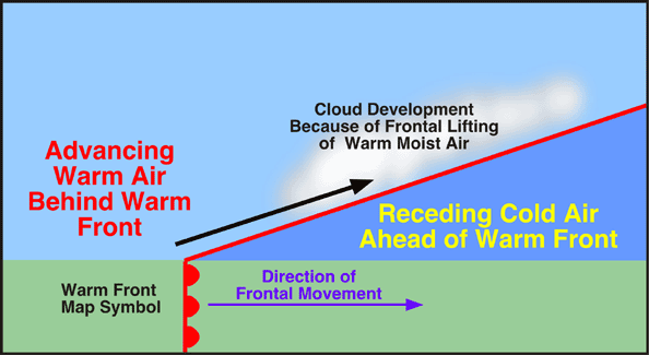
I'm not sure what you mean, but the front is symbol is always located where the two air masses meet at ground level. In this picture, you can see the warm front is actually behind some of the warm air that has risen above the cold air:bubblebrian wrote:When you look at a surface weather map and look at the fronts, does the front symbol mean the beginning of the front where the first winds are (the "tip" of the front), or is it at the end of the front, where it totally becomes an air mass, or somewhere in between?