Sorry 'bout not posting a new question. Here's a slightly trig intensive problem I made up:
Given three outcrops, their elevations, and their distances, calculate the dip of the bed to the nearest whole number. Drawing's not to scale so you'll have to math it out on your own.
Re: Geologic Mapping C Question Marathon
Posted: September 23rd, 2013, 6:08 pm
by gneissisnice
Ah, a three point problem.
Since I'm a college student and therefore not doing the event, I'll let other people answer the question. Have fun!
Re: Geologic Mapping C Question Marathon
Posted: September 28th, 2013, 1:14 pm
by syo_astro
Mathdino wrote:Sorry 'bout not posting a new question. Here's a slightly trig intensive problem I made up:
Given three outcrops, their elevations, and their distances, calculate the dip of the bed to the nearest whole number. Drawing's not to scale so you'll have to math it out on your own.
I get about 68 degrees.
Re: Geologic Mapping C Question Marathon
Posted: October 9th, 2013, 1:59 pm
by syo_astro
Okay, I know that answer is wrong, but if you want you can just explain the answer...How about a new question? I'm going to make this one up just for the geohazard question, but I have no idea if this will be asked. Hopefully it seems legit.
This image is of Mount Rainier: http://geology.com/articles/geologist/lahar-map.gif
Say a lahar is produced by the volcano (which is surrounded by ice) while it is not active (in the past this has happened). If you were in USGS, locate places of possible risks, one escape plan for one place of risk, and three preventative measure. Also, explain the type of lahar produced in this situation and why it is dangerous.
Re: Geologic Mapping C Question Marathon
Posted: October 10th, 2013, 1:44 pm
by pikachu4919
syo_astro wrote:Okay, I know that answer is wrong, but if you want you can just explain the answer...How about a new question? I'm going to make this one up just for the geohazard question, but I have no idea if this will be asked. Hopefully it seems legit.
This image is of Mount Rainier: http://geology.com/articles/geologist/lahar-map.gif
Say a lahar is produced by the volcano (which is surrounded by ice) while it is not active (in the past this has happened). If you were in USGS, locate places of possible risks, one escape plan for one place of risk, and three preventative measure. Also, explain the type of lahar produced in this situation and why it is dangerous.
places of possible risk include Paradise and Longmire; One escape plan is to evacuate from the park to Tacoma where there is no risk according to the map; three preventative measures would be to set up shelter on high ground, increase public awareness, and practice emergency procedures. Since the volcano is not active when the lahar formed, in this case it could have been caused by heavy rain washing away sediment on the mountain side, like a watery avalanche, which is very dangerous because this characteristic of lahars makes them unpredictable, very destructive and very quick.
Re: Geologic Mapping C Question Marathon
Posted: October 10th, 2013, 2:17 pm
by syo_astro
Yeah, that's pretty much what I was thinking. Do you think that's what they'd ask basically for the hazard risks >.>? Also, I have a few questions about your answers.
Do you think someone would want more to go to Eatonville, Lake Kapowsin, or even at Sumner slightly east to that lake? Wouldn't those be closer and not have that arrow with the moderate lahar pointing past Sumner? Oh, also just to add the automated system you'd use is an acoustic flow monitor (so you'd probably set that up with some signs...but I was mainly looking for where you'd go, yeah).
Other prevention measures include attempting to block or divert the path, but of course warning systems and awareness I think are better. I sort was also wondering if you'd give the cheap response of "mapping out past lahars" .
The glaciers and snow surrounding it can melt and "hydrothermally alter the rock" with volcanic gases. These are literally termed "meltwater-generated lahars". This happens because the water becomes acidic and can weather rocks.
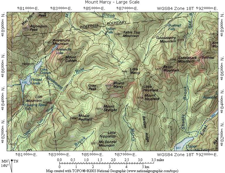
Re: Geologic Mapping C Question Marathon
Posted: October 12th, 2013, 5:36 pm
by pikachu4919
based on this topographic map, what is the best possible route to take in order to get from Lake Colden to Table Top Mountain?
Re: Geologic Mapping C Question Marathon
Posted: October 17th, 2013, 4:48 pm
by zerasaw
Haven't studied much yet but would say probably along over Mt. Colden as it does not have a major topographic prominence and a fairly even gradient. (Oh, just realized this is the Adirondacks). In addition, ascend mountain by way of stream to right of summit until first bend, then proceed straight up ridge....
Don't know really what I'm talking about and going mostly by common sense and White Mountain hiking experience, but will study...
Re: Geologic Mapping C Question Marathon
Posted: October 17th, 2013, 4:58 pm
by pikachu4919
That is possible, but I'd just like to ask why you'd want to go up and over a mountain?
Re: Geologic Mapping C Question Marathon
Posted: October 17th, 2013, 5:17 pm
by syo_astro
I wanted to let someone else answer, but I thought it would be by going down Avalanche lake and then right to Indian Falls. Alternatively, going down Opalescent river, up the side of Mount Colden and then to Indian Falls (if you know what I mean). It has an overall low gradient just by eyeing it. Also, isn't there a dashed line, and I think that's the symbol for a trail, right?
